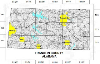
A PLSS Map stands for Public Land Survey System. A PLSS Map can be used to survey land parcels, titles and deeds of particular land. These types of maps can show land surveys of wild or undeveloped land. This particular PLSS map is of Franklin County Alabama and shows the townships and ranges. By looking at this map, you are able to identify the highlighted the towns and their particular land deeds.
http://www.rootsweb.ancestry.com/~alfrankl/landrecords.htm

No comments:
Post a Comment